By clicking "ACCEPT", you agree to be the terms and conditions of each policy linked to above. You also agree to the storing of cookies on your device to facilitate the operation and functionality of our site, enhance and customize your user experience, and to analyze how our site is used.
Public Land Boundaries Map
Quickly identify your location and land management agency details with nationwide Public Land Boundaries and easy to understand map styling.
Try Free for a Week 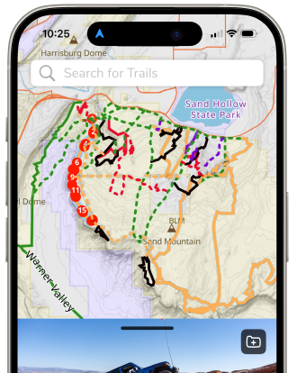
Find Offroad Friendly Adventures
See the boundaries of various land managers right in the Trails Offroad™ app and discover public lands to off-road — exclusively for All-Access Members. Understand management at a glance with colored shading or tap and hold on the map for more detail.
View Public Land Details on the Map
Get details on public land management easily with the Trails Offroad™ All-Access Basemap

Public Lands on the Map
With vibrant, color-coded shading and patterns, it is simple to identify public lands and distinguish between different management agencies.

Easy to Understand Map Legend
Select the Information icon to open the Map Legend for a quick view of road, trail, and public land styling.

Tap and Hold the Map
Find additional details like management agency district and field office names with a tap and hold on the map.
FAQs
Where does the data on Trails Offroad™ come from?
Public land boundary information is published by various management agencies and their districts, offices, etc. We work to aggregate, style, and integrate this information in an easy to understand way for our members.
Management agencies are government entities and data comes from the county, state and federal level.
How is map information updated?
The rate at which information is updated differs between each management agency. While some may update digital data sets annually, others can go nearly a decade without changes.
Does the map work without cell signal?
Offline Downloads in the Trails Offroad™ mobile app ensure you have access to all map details on a statewide basis.
Using a GPS-enabled tablet or mobile phone.
Community
Partners